Bukhansan - From Bukhansanseong to Baekwundae Trail


Hiking Bukhansan(Mt. Bukhan)
    from Bukhansanseong Park Info Center to Baekwundae(PeaK)
 

If you like to visit Bukhansan with a professional guide or if you have a half day available before you fly from Korea after a business meeting, or if you need a guide to get around in Korea, Please don't hesitate to send me an email to


  Summer was hot and is getting hotter every year. And hiking is one of the best way to get away from the heat.

  Buk-han-san (Please don't confuse with North Korea. North Korea also called   Buk-han) has many peaks and the highest peak is Baek-Wun-Dae(means a platform covered by white cloud).

  To get Baekwundae peak, one of the best way is to start at Buk-han-san-seong Park Info center. It will take 2~3 hours (depends on your condition) to get there and the distance is about 4 km from the starting point. Total hiking time will be 6 hours approximately.

  For other trail course of Bukhansan, please read my previous blog at http://hiking-korea.blogspot.kr/2013/06/bukhansan-bukhan-mountain-uisangbong.html


  Parking my car at the parking lot, we started our hiking. After passing the paved road, easy and gentle trail course welcomed us. There were some restaurants and shops in the past, but the Park Management Corporation made them move out to outside of park. Now it is very clean.
 

One of good things of hiking Bukhansan is you can enjoy this beautiful valley and stream during hiking. You can't put your foot into the water though.  


This valley is protected by some fences. If not, you will see lots of people in the water. We need to preserve this valley because it doesn't belong to us.   


The trail course is kind of poetic or you may want to sing with small sound. 


On the way, you can see No-Jeok-Bong over the ridge. NoJeokbong is on the way to Baekwundae. 


I found a cockscomb.  It is little hard to find it in city.


After passing Bukhandong, the main trail course started. From here, the real trail course has begun. The incline is not so serous but it goes long.  


Around  1:30 hours walking, we reached  a fork where leads to Won-hyo-bong and Baekundae. Left is to Wonhyobong and straight is to Baekundae.


There was a fountain on the way, but no more water and even there is, you can't drink it.  


Nojeokbong is getting closer.  


Bukhansan has lots of this kind of holders and you need to bring gloves if you don't want stains on your palms. 


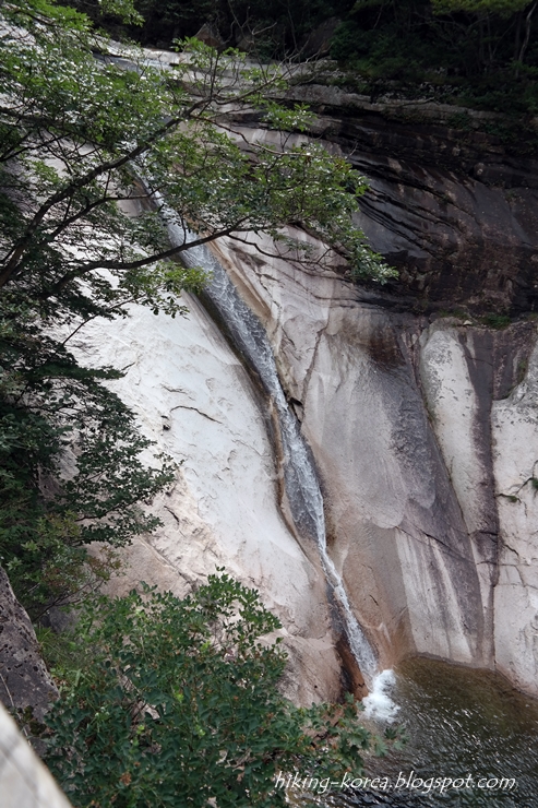
 Yak-sun-sam(means fountain rock). There was a fountain on the hole but no more. Korean believes the water from this kind of fountain can cure some disease.


Last stone steps before the gate. I will take you about 2 hours to get here.  


 Baek-wun-bong-am-mun.
The Baekwunbongammun is located between the Baekwundae and the Man-Kyeong-dae(peak, 799.5m) on Buhansan. It was built on the highest spot among the fortress gates of the Bukhansanseong. It has been called "Wie-mun" since the Japanese colonial era. It is one of secret gates which was build with the walls of the Bukhansanseong in 1711 during the reign of King Sukjong. This secret gate was used to move weapons, munitions and injured soldiers during emergencies. It was an emergency exit, but also it was installed on a hill or a mountain ridge which was easily accessible by enemies in order to protect the mountain fortress from them.


After passing the gate, the way to the top begins  

You can easily find this kind of rock and pine trees in mountains in Korea.  


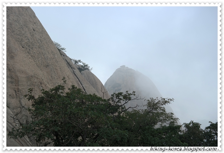
On the way to the top, In-su-bong is watching us through the cloud. 


The top, Baekwundae. A giant rock.


It looks like a sky walk, expecting heaven over there. 


Baekwundae(836.5m)  


Beneath the Baekwundae, Yeom-cho-bong is protecting Baekwundae. There was a trail course through Yeomchobong, but not any more. It was too dangerous and many people died in the past.


Insubong. But without rock climbing gear, nobody can climbing up this rock.  


On the way to other gate, I took the whole picture of Baekwundae.  


The trail route is very gentle and easy. And many cicadas are singing summer.
 

Once cicadas vanished, this forest will be full of singing of crickets.
Autumn is coming.  


 Another secret gate, Yong-am-mun.

Government is now recovering the castle wall.
That's why some stone looks very brand new.  


Near to the Yongammun. There is a shelter. 
I used to take a rest here and got some food.  


Time to get down.  


The way to down is very nice.
You can enjoy gentle breeze, cicadas' singing and smell of forest.  


At the started point, looking over the top, I thanks to the nature.

Thanks.

Seoraksan - From Osaek to Baekdamsa(Temple)

Seoraksan(Seorak mountain) is the most beautiful mountain as well as the second highest mountain in South Korea. The highest peak is Daecheongbong, 1,708m. It requires minimum 11 hours walking to touch Daecheongbong and back.  

As many mountains have, there are may ways to get Daecheongbong. And the shortest route starts from Osaek. Osaek means "Five colors" and there's a fountain where well up carbonated water tastes like soda with no sugar. The water looks like it has five colors. Also people believe the Osaek fountain is very good for stomach disorder. 


Seorak national park opens 3 o'clock in the morning everyday as long as there's no weather issue or it is not "Park closed period(Mar to May, 16.Nov to 15.Dec)". 


Thus we arrived 2:50 in the morning at the park gate in Osaek. I call is as "Overnight hiking". Our planned trail route was Osaek-Daecheongbong-Socheongbong-Bongjeongam(temple)-Gugokdam valley-Suryeomdong-Baekdamsa(temple) as you see the blue line from the map. It will takes about 11 hours and the distance is 11.8 Km. 


If you need a larger map, please send me an email.

Overnight hiking is the only way to visit Seoraksan from Seoul without consuming two full days. And only thing you have to do is leaving Seoul before 11:30 pm. You may sleep in the car. 


The mountain at 3 am was very dark and looks like something from the dark came out as we have seen in the movie. But it is just movie. No worry. Rather it is better than day time hiking as you cannot measure the inclination. Yes. the shortest way means harder incline. 


After two hours walking through darkness, we arrived at 2/3 point. It will take another two hours to hit the peak and the darkness will vanish soon. Heavy wind was blowing on the top, and the wind sounds like wave. 
I tuned off my light for a while to make myself a part of darkness. It was so peaceful moment and all distracting thoughts went away. 


Darkness was withdrawing but I found the cloud took the peak. On this kind of day, we couldn't expect watching sunrise on the peak. 


It remains 500 m to get the peak and cloudy morning has started. 


Few more steps to the peak.


Before to get the peak, I heard some instrumental sound like flute. It was very weird sound. I tried to figure what makes that sound and found this pole, no poles. The pole has holes for bolt, and the wind was playing its instrument. What a nature!  


On the top of Seoraksan(Daecheongbong), though I don't have long hair, the wind gave me some fantastic hair style. 


Very heavy wind made people stood barely and trying to ground themselves firmly. 


Beneath of the top is a big plain. The cloud look like not moving but actually it moves very fast. 


It takes about 20 mins to get Jungcheong Shelter from the top. There are several places you can stay in Seoraksan, Jungcheong Shelter is one of them and most popular. You need to make a reservation to stay here. 

Also cooking is not allowed in Seoraksan(actually in all mountains) but you can cook only in here. Personally, I don't want to bring heavy equipment to the mountain to make meal. Snacks are fine. 


Now it is time to go down. On the way to Socheongbong(peak), you can watch the beautiful part of Seoraksan. It called as Cheonbuldong valley. Cheonbul means "Thousands statue of the Budda". 

The upper part of this picture is Yangyang city and East sea.  One of the pleasure from hiking Seoraksan is we can enjoy the mountain and the sea same time. 


At the same point, if you turn your head slightly left, you can watch Gongryong Ridge. Gongryong means the dinosaur. It looks like the spine of Stegosaurus. 

This ridge is the 2nd most difficult trail course in Seoraksan. 


Now if you turn your head slightly left again, you will find the most beautiful rocks in this mountain. It called as Yong-A jangseong. YongA is tooth of a dragon and Jangseong is the castle. So it is Dragon Tooth Castle. Now this trail course has closed but when it was opening, it took 8 hours to get through this trail course. The most hardest trail course in this mountain. 

We will take the left trail course of this ridge. 


Once again, watching both Gongryong Ridge and YongA Ridge, I felt the joy from the great nature. What a wonderful world! 


Those rocks belong to YongA ridge and one of them (2nd from right) looks like a statue of the Buddha. 


And beneath the statue, there is Bongjeongam(temple). I think Bongjeongam is the highest located temple in Korea. Buddhists can stay here to pray and they visit the peak after pray. If you are not the Buddhist, you can't stay here. 

That's why you can easily find old women in this mountain. 


Passing Bongjeongam, Gugokdam valley starts. Gugokdam means "9 beautiful ponds". On Gugokdam trail course, you will find so many waterfalls and its ponds. It will take 3 hours to get down to next shelter(Suryeomdong). During trekking, if you are exhausted, you may want to sit near to the water and put your foot into water. It feels so good.   

Please enjoy the Gugokdam Valley!


This is the Double dragon waterfall (Ssangyong pokpo). Two waterfalls meet here. 


While I put my foot into water, a squirrel came to me and asked some food. I gave a small piece of bread. Yes, you will find lots of squirrels asking some food while you are on the trail.   


After 3 hours walking, we arrived at Suryomdong shelter. It will take 1:30 to get Baekdamsa where is our trail end. 


On the way to Baekdamsa, Yongsi-am is welcoming the Pilgrim. Yongsi means "I gave up my ordinary life of the world". This temple belongs to Baekdamsa.


The trail is getting gentle and easy.  


Almost there. 1.8 Km left to the goal. 


Suryeomdong is also a valley but it looks like more than valley. River. 


At last, we arrived at the Baekdamsa. Baekdamsa is famous for a monk named Han Yongwun. He fought against to Japanese during Japan invasion. 
However, this temple became more famous because one of Korean president concealed himself in this temple. 

He was a very bad president and he killed many people in Gwangju in 1980. 


Thus, our 11 hours trekking ended, from 3 am to 2 pm. 

There are so many trail course in Seoraksan and I will guide you to another trail near soon. I hope you enjoyed my blog. 


If you like to visit Seoraksan with a professional guide
or if you have a half day available before you fly from Korea after a business meeting,
or if you need a guide to get around in Korea,
Please don't hesitate to send me an email to
 
Thanks!